TECHNOLOGY
6 MINS READ
How CleverMaps Help in the Fight with Coronavirus?
See how CleverMaps uses location data for smart quarantine, virus tracking, and contact tracing—enhancing public health measures and pandemic response.

A current joyless period points out not only the negative consequences that the Coronavirus has on our lives but also encouraging social phenomena. A huge wave of solidarity has awakened in the Czech Republic and among others the COVID19CZ initiative has been created. A group of IT companies felt that if they used their know-how when it comes to data process and modern technologies they could fundamentally help the country slow down the Coronavirus spread. The central activity of the initiative is the so-called smart quarantine and memory maps that were created and operated by CleverMaps and Keboola.
Memory maps for sanitary workers
Our main weapon is and always will be the work with location data and their visualisation. For the district sanitary stations, we developed and launched the smart tracing of the Coronavirus spread with the help of location data from phones and banks already on March 20.
Thanks to the advanced data analysis, we, with the agreement of the infected person, are creating a memory map that transparently shows where and for how long the infected person moved around in the past 3 weeks. Sanitary workers are thus no longer reliant on the memory of the infected and focus on critical moments and places where the virus could have spread to other people. This way they can warn all the people who could have come in contact with the virus and will order the so-called smart quarantine (pointed quarantine). This could replace the global measures that have paralysed the whole economy.
How does it all work?
1. Sanitary stations and operators of the specially created call centre (with our software) contact the infected person telephonically.
2. The contacted person is then asked to give an agreement for the use of the geo-location data of their phone, and possibly transaction history as well.
3. Analysed data of the past three weeks is then visualised into a transparent memory map in the CleverMaps interface.
4. The call centre worker together with the infected person then goes through the memory map, locations and times where the person moved around and then creates a list of critical locations and people that the infected person visited, met and those who can be in danger of being infected.
5. Outputs from the call are in a structured form and handed to the sanitary workers who then take necessary precautions (imposing possible pointed quarantine, dispatching a disinfecting team to the location of the infected person).
6. Critical locations with virus occurrence will be examined from the point of view of endangered people who were at the location at the same time. At this point, the data from the operators and banks and mobile applications are used so that endangered people can be notified that they could have come in contact with the virus.
7. Location data must be deleted from the system 6 hours after the agreement for their use was given. In reality they are deleted immediately after the phone call is finished.
8. The audit company PwC is responsible for the correct course of action.
GDPR-friendly approach
When developing solutions we were extremely careful to sustain the privacy of all concerned. Everything is based on the GDPR values and we can assure everyone that the information about the movement of people is flowing securely only among mobile phone operators and call centre systems. The basic condition is the agreement for the use of geo-location data. Within 6 hours the latest from the agreement the data must be deleted. Both are monitored by the aforementioned auditor.
Tracing of the infection in reality
There have been hundreds of successful tracing calls and even during the first days the potential of the memory maps was demonstrated which could lead to the replacement of global state precautions and the ban on going out by smart quarantines. In order to make this happen the government must be involved in the process more and more sanitary stations throughout the Czech Republic need to be established. What does the work with the map look like? According to the size of the circle on the memory map, it is possible to determine how long the individual person stayed at the location. Only places where the infected person stayed for minimally 10 minutes are displayed.

Tracing of the infection in reality in CleverMaps Studio.
Thanks to the CleverMaps interface the call centre worker can focus on certain days and times. Rather than the time when most people sleep at home, they will be interested in the rest of the day which is more dangerous from the virus spread perspective.
The accuracy of the monitored location No data are perfect and every monitored location falls under some deflection from reality. The average accuracy of the operators’ data is with the deflection of 500m, in towns only 200m. Bank data are related to the location of the payment terminal. These combined with the call are most of the time enough to reliably determine the risk of the virus spread.
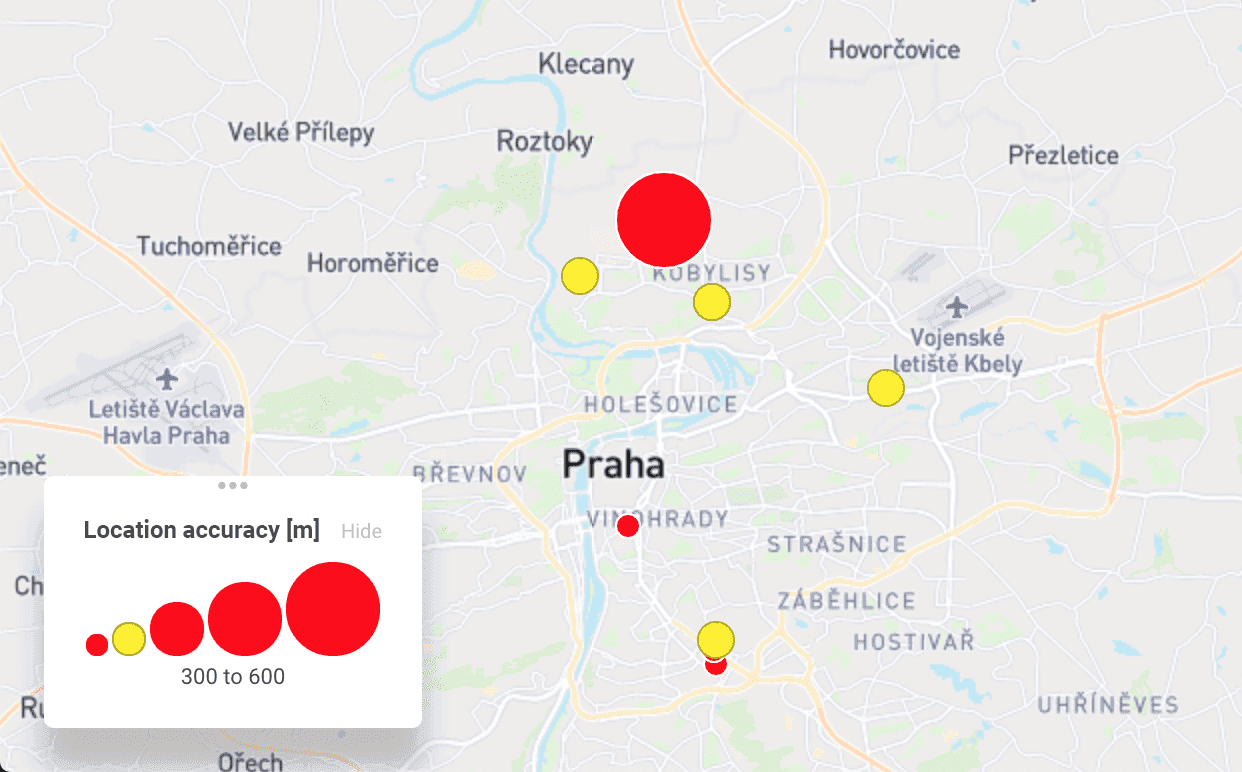
Location accuracy of COVID-19 in CleverMaps Studio.
The real size of the radius can be simulated with the help of isolines. This allows monitoring both the distance as the crow flies as well as approximate driving and walking distance from any point on the map. The software also allows turning off the least accurate records and focusing only on the locations with minimal space deflection.

Apart from the smart quarantine and memory maps, the development of the open-source respiratory units CoroVent for the Czech public health service or the development of the eRouska app that automatically notifies the user that they are moving around near a person tested positively for the Coronavirus are among the Covid19CZ projects.